The UrbanArk project aims to improve the resilience and emergency preparedness of urban centres and their communities to the threat of coastal flooding. Within urban centres, underground spaces such as storage areas, transportation corridors, basement car parks, public facilities, retail & office and private spaces (e.g., residential basements) present a priority risk during flood events with respect to timely evacuation. However, often the location, geometry and volume of these underground spaces are not well known. Furthermore, these underground spaces are commonly not considered in urban flood prediction models. At the same time, communicating flood risks and enhancing emergency preparedness poses further challenges. The use of urban underground spaces is highly varied ranging from residential to office space to retail and the perception of risk differs from one user community to the next. Thus emergency planners need engaging communication tools to increase community resilience and preparedness to flooding events.
Low-cost Mobile Laser Scanning (MLS) and Airborne Laser Scanning (ALS) technologies as well as other remote sensing applications and street view imagery data are becoming increasingly available and affordable, providing high-resolution data for the urban environment. However, these technologies produce vast amounts of data that require efficient means for storing and querying the information in order to make them useful for other applications.
UrbanARK focuses on gaining better knowledge of the location and internal geometry of underground spaces in urban centres by using low-cost MLS data together with street view imagery. The project will develop efficient database approaches, including cloud computing, to handle the large data sets and to integrate the information into flood prediction models. These models will provide refined information on urban flood levels and flooding rates into the underground spaces, which in turn will be used as part of a newly developed risk communication tool comprising a low-cost virtual reality application. This tool will then be able to communicate the local flood risks to urban communities directly providing an immersive experience of flood risk with the aim to better engage communities in emergency preparedness, thus increasing community flood resilience.
To address the related problems of improved flood prediction and enhanced risk communication, UrbanARK will focus on the social, scientific and technical challenges of coastal flood Disaster Risk Reduction (DRR) with a particular focus on underground spaces. In this program, the following questions will be explored:
- How best to identify and volumetrically estimate underground spaces not captured in existing documentation by efficiently using opportunistic spatial surveying and imagery data;
- How to rapidly and cost-effectively acquire high-resolution spatial survey data of the internal geometries of identified underground spaces;
- How to (1) store, curate, and query these various data efficiently, (2) make them unifiable with other data, and (3) enable their access by non-technical officials and public stakeholders;
- How to integrate spatial data of street-scale underground spaces with available regional spatial data to refine regional flood models to better model flood rates and inundation levels;
- How to employ the high-resolution spatial data and refined flood models to improve emergency planning and risk communication to improve DRR and resilience of urban occupants;
- How best to deliver highly localized flooding risk warning information to local officials and residents so that the relevancy of the information is clear and that those receiving the information feel that they have sufficient agency to take action (e.g. evacuate).
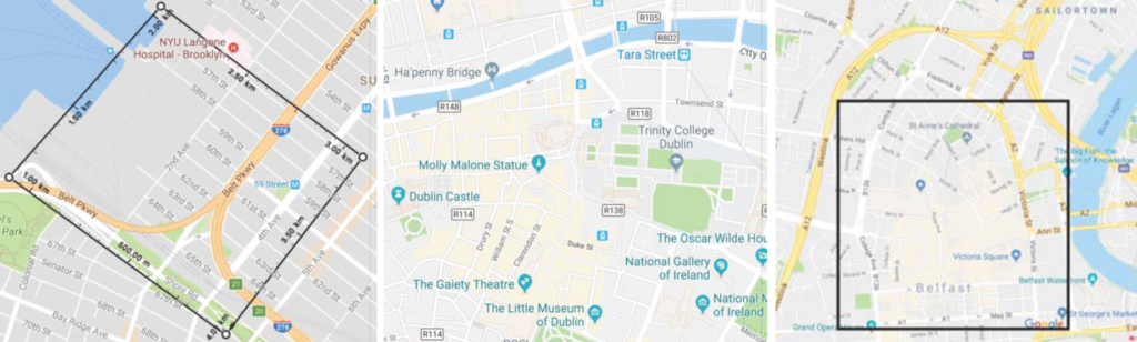
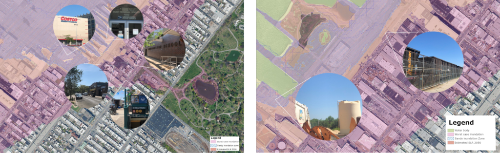
To achieve these goals, UrbanARK has partnered with local authorities and governmental agencies to address coastal flood risk assessment and communication in the context of three (3) US and Irish study areas (New York, Belfast, and Dublin). In each case, a 1 km2 area will be considered. Each study area has its distinctive character: (1) the New York neighborhood is a mix of mid-20th century, low-rise residential units bisected by a major highway and flanked by large, industrial, port-related facilities, (2) the Dublin area is a mix of residential, retail, and governmental units characterized by a significant number of closely spaced, late 18th century and 19th century historic masonry structures, typical 4-story with a basement, and (3) the Belfast area has significant retail facilities in its mixed-use historic center with extensive subsurface parking and below-grade office space. In combining the three study areas, the investigations cover the range of different underground structures typically encountered in coastal urban centres, including a broad mix of urban communities.
UrbanARK‘s six (6) Work Packages (WP) are designed to build on the respective institutional strengths of the tri-partite collaborating research teams at Queen’s University Belfast (QUB), New York University (NYU) and University College Dublin (UCD) while fostering regular cross-fertilization and synergistic team building. In doing so, UrbanARK interweaves the research expertise of civil engineers, social scientists, geomaticians, and computer scientists to develop the next generation of flood DRR.
- Work Package 1: Identification and Capturing of Underground Structures
- Work Package 2: Database Development
- Work Package 3: Development of Graphical User Interface
- Work Package 4: Refining Hydrodynamic Coastal Flood Models using High-Resolution LiDAR and Hyperspectral Data
- Work Package 5: Population Risk Awareness and Past Behaviour Surveys
- Work Package 6: Risk Communication Tool Development
US National Science Foundation (NSF Award 1826134) and Science Foundation Ireland (SFI 17/US/3450)